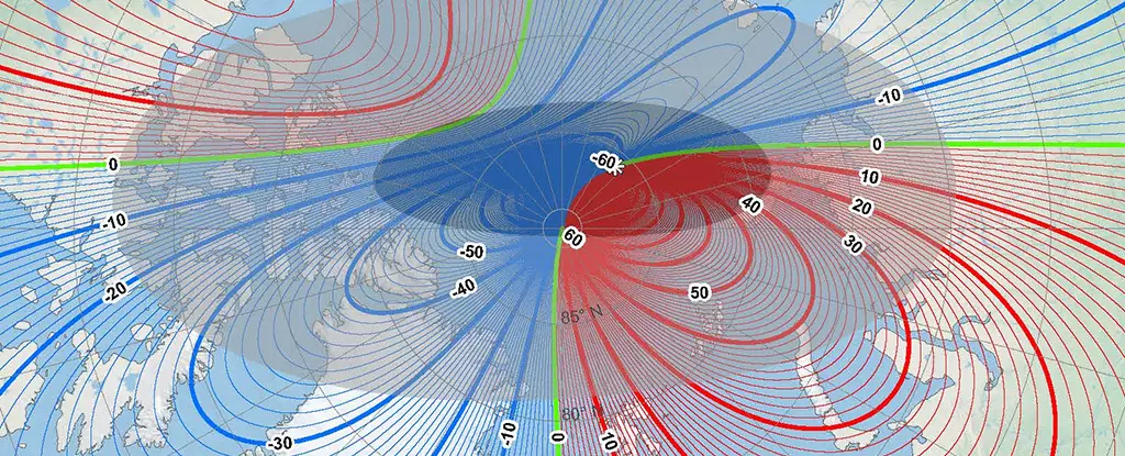
In a world that relies heavily on precise navigation tools, the continual movement of the magnetic North Pole presents significant challenges and opportunities for recalibration. As the magnetic North Pole drifts further away from Canada and approaches Siberia, experts are calling upon navigational systems across various sectors—from maritime travel to aviation, and even the annual journey of Santa Claus—to recalibrate their methodologies. In collaboration with the US National Oceanic and Atmospheric Administration (NOAA) and the British Geological Survey (BGS), researchers have embarked on a crucial mission to refresh the World Magnetic Model (WMM), ensuring navigational accuracy for the next five years.
The need for this recalibration stems from the fundamental distinction between the magnetic and geographical North Poles. While the latter remains fixed at the Earth’s rotational axis, the former is subject to constant fluctuations influenced by the movements of molten iron and nickel in the Earth’s core. Understanding the intricacies of this magnetic field is vital for those using compasses or GPS systems, as even minor discrepancies can lead to substantial navigational errors.
According to global geomagnetic modeller William Brown from BGS, the behavior exhibited by the magnetic North Pole is unprecedented. While it has been migrating in a relatively stable manner for centuries, its acceleration towards Siberia over the past two decades has been striking. Initial movements were recorded in the early 2000s, where the pole shifted at a rate of 50 kilometers (31 miles) annually. Remarkably, this rate began to decelerate around five years ago, sharply dropping to approximately 35 kilometers (22 miles) per year, marking a historical shift in its traveling patterns.
Research has identified the presence of two colossal magnetic lobes—one beneath Canada and the other beneath Siberia—driving this continuous migration. Changes in these magnetic lobes contribute to the dynamic movement of the magnetic North Pole, necessitating frequent updates to navigational systems that utilize this data. The implications are far-reaching, affecting everything from global shipping routes to personal navigation systems.
One of the most remarkable advancements resulting from this collaborative effort between NOAA and BGS is the release of a higher resolution WMM. This upgraded model offers a spatial resolution nearly ten times greater than its predecessor, measuring 300 kilometers at the equator compared to the previous standard of 3,300 kilometers. Such an enhancement allows for more precise tracking of the magnetic North Pole, which is crucial for industries that rely on accurate navigational data.
For example, a journey spanning 8,500 kilometers (5,282 miles) from South Africa to the UK would result in a staggering 150 kilometers (93 miles) error using the former model. By contrast, the updated WMM promises to mitigate such discrepancies, ensuring better accuracy in both professional and recreational navigation.
The significance of the updated WMM cannot be overstated. As logistics companies, governmental bodies, and maritime agencies begin to implement changes based on this new model, the accuracy of GPS systems will improve not only for commercial use but also for everyday consumers. Notably, users of phones and satellite navigation devices can expect automatic updates, minimizing disruption from manual recalibrations.
Additionally, the timing of this update is particularly fortuitous, coinciding with the festive season where figures like Santa Claus are iconically associated with navigation. As the BGS highlights, the enhanced model is crucial for ensuring that all navigational systems—whether for commercial use or holiday travel—are accurate.
As we adapt to the realities of a shifting magnetic North Pole, the partnership between NOAA and BGS lays the groundwork for enhanced navigation systems that are fundamental in our increasingly connected world. The implications of these shifts extend beyond simple navigation; they affect global commerce, safety, and even cultural practices. With better models at our disposal, we can expect to traverse the globe more accurately than ever before, ensuring that we never lose our way, whether navigating the streets of bustling cities or the starry skies above.


Leave a Reply